If there is anybody who has not yet seen this, it is Enbridge's idea of Douglas Channel linking Kitimat with Hecate Strait. In reality, about 1,000 square kilometres of islands dot the channel making it considerably harder to navigate with a super-tanker than this view of a 20 to 30 kilometre wide, unimpeded waterway would indicate. Enbridge explained that the image was meant to be "broadly representational".

In the spirit of "broadly mis-representaltional" imagery, this shows approximately where the supertanker shown in the image above would be, hard aground on Hawkesbury Island at an elevation of about 500m. With the cloud and the viewing angles involved, the location might actually be in Evelyn Lake which would seem much more appropriate except it would be hard to imagine how the Captain and crew could have put her in there without some damage to the hull - mega-tsunami perhaps. No real problem with getting out, just wait until enough fossil fuels have been burned to raise the ocean level to the point where she could be driven out.
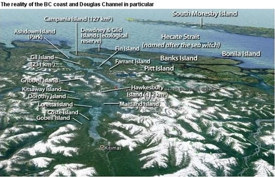
This is a true (Google Earth) representation of Douglas channel from about the same vantage point as the Enbridge image above. Imagine how the captain of the first super-tanker in would feel as he looked at the 'special' chart supplied by Enbridge and compared it with the view ahead.
A satellite view of Douglas Channel from Kitimat to Hecate Strait and yes . . . the islands are all there all right.
MY WEBSITE — ANewHumanity.CA
FACEBOOK PAGE
Send me an eMail message to: john@anewhumanity.ca
THIS POST